Category: World History

  • Edo Before Tokyo: Life in the Shogun’s City

    Edo Before Tokyo: Life in the Shogun’s City

    Fish sellers cluster with their baskets at the near end of Nihonbashi. Behind them, a formal procession advances across the bridge. Utagawa Hiroshige’s woodblock print brings these groups into the same morning scene: people moving through a city whose commerce and official life share the street. The picture, made around 1833–34, gives us a place to begin exploring Edo before it became Tokyo. The Met: Hiroshige’s Nihonbashi

    It is an arranged artistic composition, with choices about viewpoint, colour and detail. Those choices are part of its historical interest. To understand the city, we can put the print beside guidebooks, other images and surviving objects, each revealing a different activity or expectation.
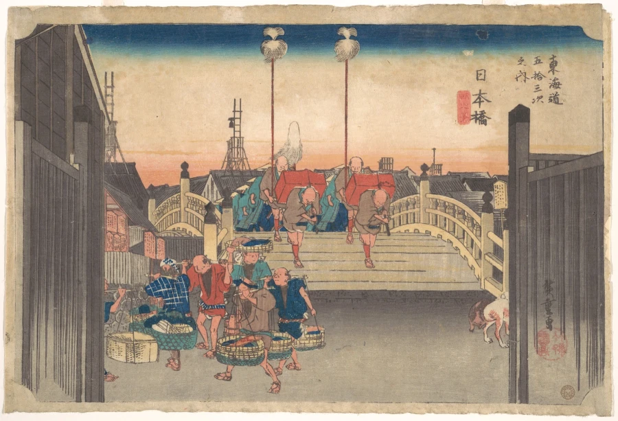
    Hiroshige woodblock print of a procession crossing Nihonbashi, with fish sellers and baskets in the foreground.
    Utagawa Hiroshige’s view of Nihonbashi, about 1833–34, places a daimyō procession behind fish sellers at the bridge. Historical woodblock print. The Metropolitan Museum of Art, JP471. Image: CC0. Source · Rights

    The shogun’s city

    Tokugawa Ieyasu established his shogunate in Edo in 1603. The shogun headed Japan’s warrior government, while the emperor remained in Kyoto. Edo grew as a centre of political power and urban culture during the long Tokugawa period. In 1868, the shogunate’s collapse and the Meiji Restoration brought a new political order, and Edo was renamed Tokyo. Tokyo Metropolitan Government: the city’s history

    The focus here is mainly the eighteenth and nineteenth centuries. Edo’s identity as a seat of government mattered, but official institutions alone cannot explain a city’s daily life. Traders, artisans, performers and the people serving a large urban population shaped its streets and its cultural production. The Met’s account of the period places merchants and craftspeople at the centre of much of this artistic activity. The Met: urban culture in the Edo period

    A bridge between official and commercial life

    Nihonbashi stood at the starting point of the Tōkaidō road from Edo towards Kyoto. Hiroshige depicts a daimyō procession: the travelling household and attendants of a regional lord. The fish sellers in the foreground belong to the nearby market. A major route, formal movement and the business of supplying food meet in one composition. The Met: the procession and fish sellers

    Travel by regional lords was part of the Tokugawa political system. Under sankin-kōtai, they spent alternating periods resident in Edo. The resulting movement supported roads, lodging and transport. Other travellers also used these routes, although journeys were subject to restrictions and often took the form of pilgrimages. National Diet Library: travel and famous places

    The image therefore connects the city to places beyond its edge. Goods and people arrived, passed through and departed. A bridge was a physical crossing and a point around which different kinds of urban activity could gather.

    A city people could read about

    Guidebooks introduced Edo’s famous places, shops and products. The National Diet Library’s collection shows that they served residents as well as visitors and could be bought as souvenirs. Their subjects included temples, shrines, entertainment and commercial destinations. Readers could approach the city through a publication before visiting a place in person. National Diet Library: Edo guidebooks

    Some publications promoted particular businesses. A guide describing where to shop or eat is evidence of how sellers wanted to be found, alongside evidence of the goods and services on offer. Its selections require interpretation: a place’s appearance in a guide does not tell us how frequently every resident could afford to visit it.

    Famous-place images extended this culture of looking. Outings, journeys and recognised views supplied subjects for prints. The National Diet Library connects the popularity of these images with the growth of travel and urban leisure. A view could bring an unfamiliar destination closer or recall a place someone had already visited. National Diet Library: the appeal of famous-place pictures

    Many hands behind a famous artist’s print

    Ukiyo-e, usually translated as pictures of the “floating world”, includes prints associated with actors, entertainment districts and famous places. Their production depended on cooperation. An artist supplied a design, carvers prepared blocks, printers transferred the image to paper, and a publisher organised the commercial venture. The artist’s name identifies only one part of this work. The Met: the makers of a woodblock print

    Colour printing required the impressions from separate blocks to align on the sheet. A finished print thus records skilled manual coordination as well as a design. Repeated impressions allowed an image to circulate among buyers, linking artistic production with the demand for recognisable people, fashions and destinations.

    This shared labour is worth remembering when looking at Hiroshige’s bridge. The scene comes to us through a designed and manufactured object. It travelled through a market of its own, even as it pictured commerce in the city.

    Theatre beyond the stage

    A second print shows the Kabuki actor Ōtani Oniji III in the role of Yakko Edobei. Kabuki is a form of Japanese theatre known for its stylised performance. Tōshūsai Sharaku made the portrait in 1794. The leaning body, spread hands and forceful expression present a character in performance. The museum identifies the role as a samurai’s servant in a named play. The Met: Sharaku’s actor portrait

    Woodblock portrait of a Kabuki actor leaning forward with both hands spread in a dramatic pose.
    Ōtani Oniji III as the character Yakko Edobei, portrayed by Tōshūsai Sharaku in 1794. Historical woodblock print. The Metropolitan Museum of Art, JP2822. Image: CC0. Source · Rights

    An actor portrait carries theatrical culture beyond the moment of performance. The viewer can recognise a performer or encounter a role through the image. Sharaku’s exaggeration makes that relationship especially visible: the pose asks to be read as part of a performance. Treating it as a straightforward record of ordinary behaviour would lose what the artist is doing.

    For the history of everyday life, leisure deserves attention alongside work. A city needed food and transport, but residents also sought entertainment, spent money on images and formed attachments to familiar performers. The prints preserve some of that world of attention and consumption.

    Fire as an urban danger

    Edo’s wooden buildings and crowded conditions made fire a recurring hazard. A surviving firefighter’s ensemble introduces the material response: thick quilted cotton, an outer coat, an inner jacket and trousers. Such coats could be reversible, with a comparatively plain indigo exterior and elaborate imagery inside. The Met: a firefighter’s clothing

    A dark blue quilted firefighter’s coat, inner jacket and trousers displayed on a museum mannequin.
    A Japanese firefighter’s quilted cotton ensemble, mid-19th century, catalogued to the Edo or Meiji period. The Metropolitan Museum of Art, 1983.158a–c. Image: CC0. Source · Rights

    The Met dates this example to the middle of the nineteenth century and allows either an Edo or Meiji attribution. Its decorated lining includes a scene associated with the deity Susanoo. The garment combines practical construction with visual identity. The museum display helps us examine it, while its uncertain period prevents us from assigning it confidently to a particular moment in Edo’s history.

    A coat cannot tell the whole story of how a fire was fought. It does make the person carrying out dangerous urban work more tangible. Placed beside the bridge and actor prints, it widens the range of lives through which we can approach the city.

    Edo within a wider world

    Tokugawa authorities controlled foreign contacts, but connections continued. Restricted trade with Chinese and Dutch merchants at Nagasaki provided channels through which goods and ideas reached Japan. Edo’s distinctive culture developed within that setting of regulated exchange. The Met: continuing overseas contacts

    The city emerges from these sources as a place of movement and skilled work: a procession crossing a bridge, a publisher commissioning an image, a performer being recognised, a firefighter putting on a coat. Each source offers a partial view. Together, they help us follow urban life beyond the residences of rulers and into the places where people bought, watched, travelled and worked.

    For another setting in which public buildings and entertainment shaped an urban community, explore life in Roman Stobi. The cities belong to different periods and institutions; their surviving material asks a shared question about how people used the spaces around them.
  • Water for a Maya City: The Reservoirs of Tikal

    Water for a Maya City: The Reservoirs of Tikal

    Tikal’s temples rise above the forest of northern Guatemala. Their builders also reshaped the ground closer to people’s feet: plazas, channels, dams and reservoirs helped gather and retain water. The city’s monumental centre belonged to a wider inhabited landscape, with residences extending beyond the great ceremonial spaces. Supplying that population required attention to the months when rain was scarce. UNESCO: Tikal National Park

    The reservoirs make it possible to investigate that work. Excavated structures reveal construction and repair, while sediments preserve traces of minerals, plants and contamination. Together, they expose two connected problems. The city needed enough water to last through dry periods, and that water needed to remain usable.

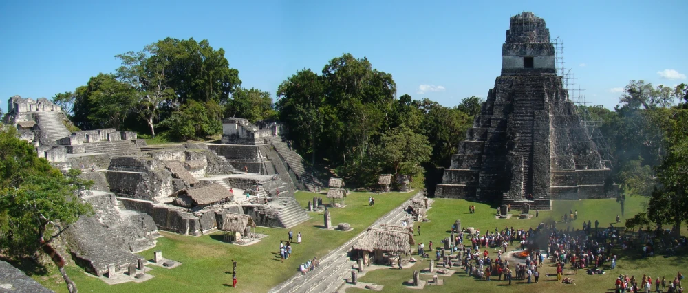
    Temple I and stepped structures around Tikal’s Great Plaza, with trees and visitors below.
    Temple I and the North Acropolis at Tikal, seen from Temple II in December 2010. Monumental spaces formed part of a much wider urban landscape dependent on managed water supplies. Bjørn Christian Tørrissen / Wikimedia Commons · CC BY-SA 3.0.

    A city and its water landscape

    The focus here is Tikal during the Maya Classic period, approximately 250–900 CE, with earlier reservoir development as background. A catchment is the area from which water drains towards a particular basin. At Tikal, construction altered both the basins and the surfaces supplying them.

    Living with a seasonal supply

    A tropical forest does not guarantee a dependable water supply in every season. In the southern Maya lowlands, rainfall varies substantially over the year. Tikal’s elevated centre had no large perennial river or lake immediately beside it. Stored water helped bridge the dry months, while rainwater moving over the inhabited landscape brought its own challenges. Water could carry sediment and waste as well as replenish a reservoir. Lucero, Gunn and Scarborough: seasonal water management

    Archaeologists have also identified a small spring in the Temple Reservoir area that may have attracted early settlement. As the city grew, water management became much more extensive. The system developed through successive modifications to a landscape that already had slopes, depressions and natural drainage. Scarborough and colleagues: the Temple Reservoir and early spring

    Turning the city into a catchment

    Research published in 2012 traced how Tikal’s builders adapted natural drainage and used constructed surfaces to direct runoff. Paved areas helped channel rain towards storage, while dams held water at different elevations. The Palace Reservoir, below the Temple Reservoir, was retained by a substantial dam. Reservoirs and monumental construction formed parts of the same altered terrain. Scarborough and colleagues: reservoir construction

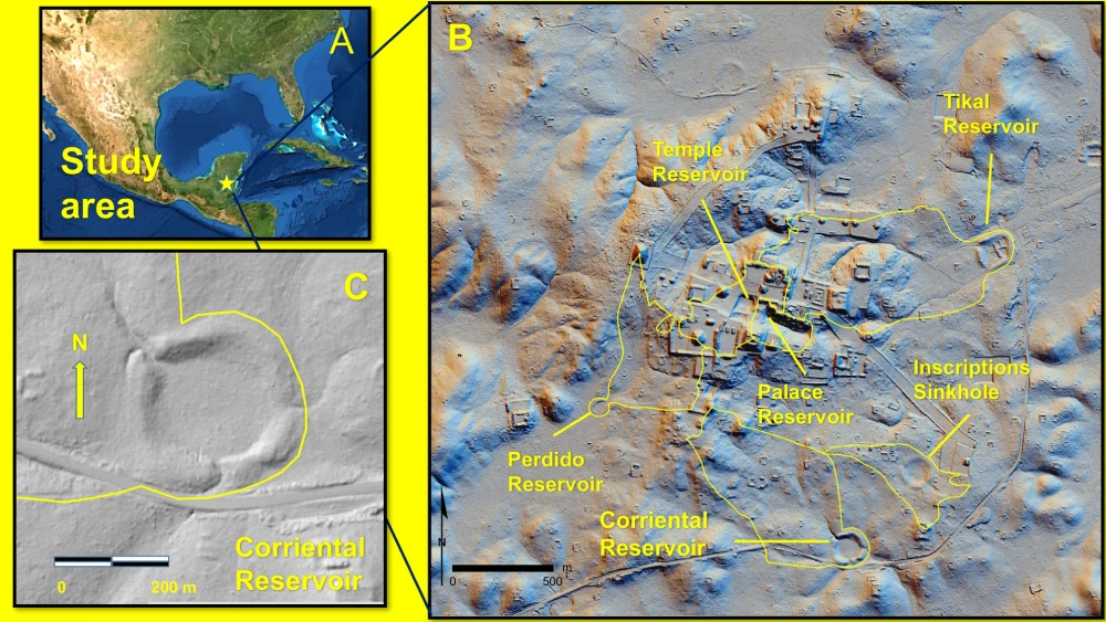
    Three-panel research map locating Tikal, named reservoirs and catchments, with a lidar detail of Corriental Reservoir.
    A research map of Tikal’s reservoirs and catchments, including Corriental Reservoir. Published as Figure 1 in Tankersley and colleagues’ 2020 study. Tankersley et al. (2020), Fig. 1; hillshades: Francisco Estrada-Belli / PACUNAM; GIS: Christopher Carr · CC BY 4.0. Open the full-size figure.

    The research map helps separate individual reservoirs and their catchments. Corriental, for example, occupied a different part of the system from the Temple and Palace reservoirs. That distinction becomes important when their sediments are compared: water from different surrounding surfaces did not necessarily acquire the same materials or contaminants.

    A catchment therefore extends the history of a reservoir beyond its visible edge. Conditions uphill could affect what arrived in the basin. The people maintaining a water supply had to work with this relationship between the storage space and the landscape feeding it.

    Storage needed continuing work

    Excavation shows that Tikal’s water structures were repaired and remodelled. At the Palace Dam, investigators found evidence of collapse followed by an attempt at repair. They also interpret the arrangement between the Temple and Palace reservoirs as permitting work on the lower basin while water remained held above. Such interpretations concern the operation of a system, not simply the size of its original construction. Scarborough and colleagues: Palace Dam and maintenance

    Maintaining usable storage meant more than waiting for rain. A basin could lose capacity as material accumulated, and damage to a retaining structure could change where water flowed. The archaeological traces of repair bring recurring work into a history often told through the completion of impressive monuments.

    Mineral clues to filtration at Corriental

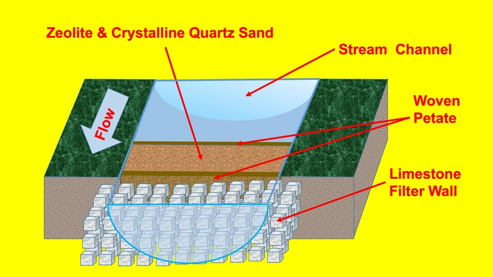
    In a study published in 2020, Kenneth Barnett Tankersley and colleagues reported zeolite minerals and coarse quartz in Corriental’s sediments. They proposed that these materials had been brought to the reservoir for filtration. Zeolites have porous structures and chemical properties that can capture certain contaminants; their presence here gives the argument a specific material basis. Tankersley and colleagues: mineral evidence and filtration

    Research schematic showing water flowing through quartz sand and zeolite held by woven mats and a limestone filter wall.
    A proposed quartz-and-zeolite filtration arrangement at Tikal, published as Figure 4 in Tankersley and colleagues’ 2020 study. Its construction details are hypothetical. Tankersley et al. (2020), Fig. 4 · CC BY 4.0. Open the full-size figure.

    The diagram illustrates the authors’ proposed arrangement. It places filtering material near an inlet, held by woven material and stonework. The complete structure shown was not recovered intact. The minerals are observed evidence; the detailed arrangement is a reconstruction intended to explain how they could have functioned.

    This distinction leaves room to appreciate the proposal without turning it into a modern performance certificate. We cannot use the diagram to calculate how effectively every contaminant was removed in every season. It presents a plausible technique for improving water within a much larger system of collection and storage.

    Trees were part of the urban setting

    A different investigation asked what grew near the Temple and Palace reservoirs. In 2021, researchers analysed environmental DNA, fragments of genetic material preserved in sediments. Their results supported the presence of native forest vegetation around these central water spaces, rather than a simple picture of reservoir banks planted entirely with crops. Maize was not clearly identified in the analysed samples. Lentz and colleagues: environmental DNA and reservoir vegetation

    The authors suggest that trees could have provided shade and other benefits, alongside their role in the landscape. More specific ideas about recreational or symbolic uses remain interpretations. The evidence supports a city in which substantial architecture and vegetation existed close together. Modern forest covering abandoned buildings should not obscure the possibility of trees within the inhabited ancient city.

    Water quality varied between reservoirs

    Storage also created vulnerabilities. Another 2020 study, led by David L. Lentz, found elevated mercury and phosphate in the Temple and Palace reservoir sediments, together with DNA evidence of cyanobacteria belonging to groups capable of producing toxins. The researchers identified serious contamination associated with the later centuries of occupation. They proposed that mercury-containing cinnabar pigment used in the urban centre was an important source of pollution. Lentz and colleagues: reservoir contamination

    Corriental produced a different pattern, with substantially less evidence of the contamination affecting those central reservoirs. The findings therefore describe variation within Tikal’s water supply. They do not justify declaring that every reservoir was equally polluted.

    The methods also set limits. Ancient sediments preserve chemical and genetic traces, rather than a sample of water drawn from someone’s drinking vessel. Evidence of potentially toxic organisms is significant, but it cannot identify who drank from a particular reservoir or establish a diagnosis for an individual inhabitant.

    Water and the city’s changing future

    The decline of Tikal’s population and political institutions around the end of the Classic period occurred within wider changes in the Maya lowlands. Researchers connect episodes of drought with stresses on water supplies, farming and royal authority. The contamination findings add another possible pressure; they do not settle the whole question of why people left particular places. Lucero, Gunn and Scarborough: drought, rulers and farming communities

    The loss of a royal centre also differs from the disappearance of a people. Maya communities continued after the decline of Classic cities and remain part of the region’s present. Water history is most revealing here when it follows changing choices and circumstances, rather than compressing many lives into a single moment of “collapse”.

    Tikal’s reservoirs sustained urban life for centuries. Their remains preserve both successful adaptation and problems that accumulated over time. Looking beyond the temples brings the city’s dependence on maintenance, vegetation and water quality into view. For an earlier and very different urban water setting, explore the wells and drains discussed in the cities of Harappa and Mohenjo-daro.

  • Roads, Rivers and Sea Routes: How the Balkans Connected Worlds

    Roads, Rivers and Sea Routes: How the Balkans Connected Worlds

    A paved road above Kavala, an inscription beside the Danube and a harbour at Dubrovnik preserve three different histories of movement. Each depended on a particular combination of terrain, construction and political power. A road needed repairs; a river crossing could become a military target; a ship needed people willing to finance its voyage.

    These places help explain how communities in the Balkans connected with wider worlds. Our examples begin with the Roman Via Egnatia in the second century BCE, turn to Trajan’s Danube frontier around 100 CE, and then move forward to medieval and early modern Ragusa, now Dubrovnik. They belong to different networks and centuries.

    Three connections, three settings

    Across land
    The Via Egnatia linked Adriatic ports with Macedonia and destinations farther east.
    Along a frontier
    Roman engineering changed movement beside and across the Danube.
    Out to sea
    Ragusa built a maritime economy supported by shipyards, investment and commercial rules.

    A road between the Adriatic and the Aegean

    The Via Egnatia took its name from Gnaeus Egnatius, the Roman official associated with its construction in the second century BCE. A bilingual milestone found west of Thessaloniki records his name and a distance from Dyrrhachium, modern Durrës in Albania. The stone connects an identifiable official with an organised, measured route. Travellers coming from Italy could cross the Adriatic to Dyrrhachium or Apollonia and continue overland towards Macedonia. Livius: the road and its milestones

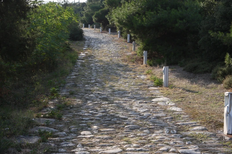
    Stone-paved path curving uphill between trees and white marker posts at Kavala.
    Surviving paving on the Via Egnatia at Kavala, Greece, photographed in 2011. The route was maintained and altered over many centuries. Philipp Pilhofer / Wikimedia Commons · CC BY-SA 3.0.

    The geographer Strabo describes the route in his Geography, drawing on the earlier historian Polybius. His account follows it through Lychnidus, modern Ohrid, and Heracleia near modern Bitola, towards Edessa, Pella and Thessaloniki. He also describes milestones and discusses the conversion between Roman miles and Greek stadia. Even an ancient description of a road involved translating between systems of measurement. Strabo, Geography 7.7.4

    Read as a journey, this sequence is more informative than a straight line across a map. Ports provided entry points, mountain country channelled movement, and cities offered successive destinations. A traveller could use a short section for a local purpose without ever crossing the whole peninsula. The same corridor could therefore matter at several scales: to a nearby town, to a provincial administration and to someone travelling much farther.

    The places along the way

    Farther east, Philippi shows how a route became part of urban history. The city acquired Roman public buildings, including a forum, after the battle fought nearby in 42 BCE. Its later Christian importance was associated with Paul’s visit in the first century CE. The surviving monuments bring military, civic and religious histories into the same place, although their buildings and uses developed at different times. UNESCO: Archaeological Site of Philippi

    The road itself changed too. Milestones record repairs under emperors including Marcus Aurelius and Septimius Severus, and Procopius later described work under Justinian in the sixth century CE. Maintenance was part of the route’s history. The paving photographed at Kavala should be understood within that long sequence of use and alteration; its appearance cannot date every stone to the first Roman construction. Livius: repairs and later use

    Engineering a difficult river corridor

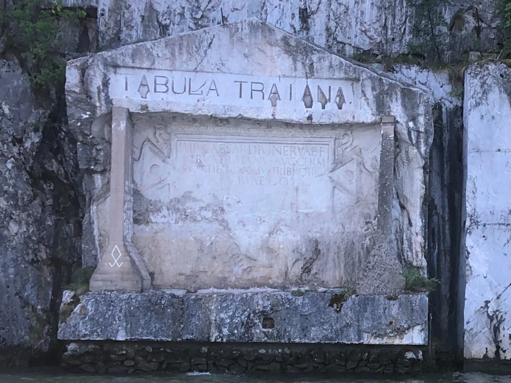
    On the Danube, the relationship between water and land required a different response. The Tabula Traiana, on today’s Serbian bank in the Iron Gates region, commemorates road works completed in 100 CE. Its Latin text names Trajan and describes the work on the difficult rocky route. The monument makes the effort visible while assigning the achievement to the emperor. Institute of Archaeology, Belgrade: inscription and date

    A weathered Latin inscription set into a rock face beneath the large lettering Tabula Traiana.
    The Tabula Traiana commemorates road works completed in 100 CE beside the Danube. Photographed in 2019, the monument occupies the higher position to which it was moved in 1969. Sanja026 / Wikimedia Commons · CC BY-SA 4.0.

    This plaque concerns the road beside the river. A separate project, Trajan’s bridge across the Danube, addressed the problem of crossing it. Cassius Dio’s account admires the bridge’s construction in deep, turbulent water and explains its military purpose: helping Roman forces reach the opposite bank. His narrative also says that Hadrian later removed the superstructure because the crossing could assist an enemy entering Roman territory. This is Dio’s explanation of the decision, preserved in the surviving epitome of his history. Cassius Dio, Roman History 68.13–14

    The reversal is revealing. The usefulness of a connection depended on who controlled it and who might approach from the other side. Easier movement could serve trade and communication, but it could also support conquest or expose a frontier. Calling the Danube a boundary captures only part of that relationship.

    Today’s view has another historical layer. The Tabula Traiana was moved to a higher position in 1969 because the Iron Gates hydroelectric project would raise the water level. The present relationship between inscription, cliff and water is consequently shaped by modern engineering as well as Roman construction. National Tourism Organisation of Serbia: the monument’s relocation

    Ragusa’s connections began at the harbour

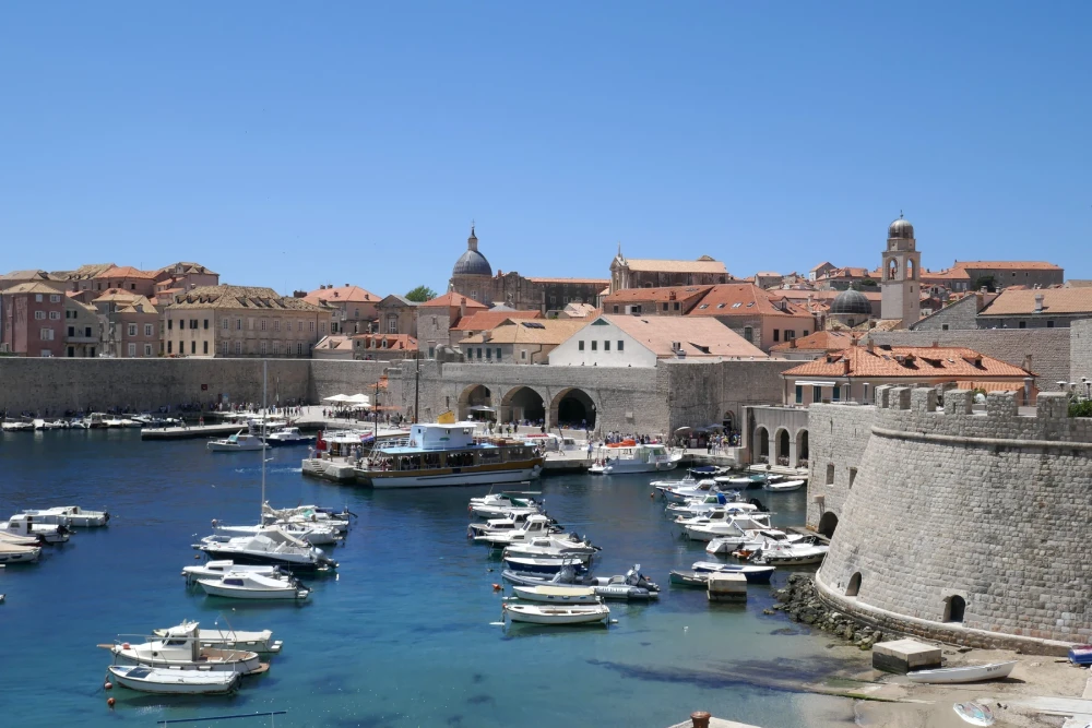
    Move forward more than a millennium to the eastern Adriatic. Dubrovnik, historically also called Ragusa, became an important Mediterranean maritime power from the thirteenth century onwards. Here the connection with wider markets depended on a city’s shipping economy. The harbour was a place where maritime journeys met the activities and resources of the surrounding community. UNESCO: Old City of Dubrovnik

    Small boats in Dubrovnik’s old harbour, with stone waterfront buildings, city walls and red roofs.
    Dubrovnik’s old harbour in 2025. Medieval and early modern Ragusa connected this Adriatic coast with wider maritime markets. Tiia Monto / Wikimedia Commons · CC BY 4.0.

    Maritime historian Đivo Bašić describes sea trade and land trade as interconnected foundations of Ragusa’s economy. His account also places shipbuilding beyond the old city harbour: yards operated at Ston and on nearby islands, while a new yard at Gruž dates to 1526. The vessels associated with Ragusa therefore depended on a wider coastal zone of skilled work. Bašić: shipping, trade and shipyards

    Commercial institutions mattered alongside physical facilities. Ragusa enacted a maritime insurance law in 1568, providing a formal framework for a business in which voyages exposed property to loss. Bašić also records attacks on Ragusan ships by pirates from Rhodes in 1507–1509. Such evidence makes the uncertainties of sea connections concrete: a harbour and a seaworthy vessel did not guarantee a successful arrival. Bašić: maritime risk and insurance

    Insurance did not remove those dangers. It organised financial responsibility around them. Seen together, shipyards and insurance rules reveal two kinds of work behind a route: making movement physically possible and making its risks manageable enough for people to participate.

    Connections had to be sustained

    The old harbour photograph records Dubrovnik in 2025, after centuries of rebuilding. The earthquake of 1667 alone substantially changed the city. Its surviving waterfront helps locate Ragusa’s maritime past, while the history of that past still depends on records of people, institutions and voyages. UNESCO: damage and surviving heritage

    Across these three examples, geography provided opportunities and obstacles. Decisions about construction, repair, defence and investment determined how those possibilities were used. This gives the Balkans’ connected history a human scale: a milestone, a difficult crossing and an insured voyage each reveal work that a line on a map leaves out.

    For the region’s changing geographical definitions, return to What Are the Balkans—and Where Do They Begin? The published chapters are collected in The Balkans: A Connected History.

  • What Are the Balkans—and Where Do They Begin?

    What Are the Balkans—and Where Do They Begin?

    Follow the Danube through the Iron Gates gorge, look south towards Thessaloniki, or trace the Adriatic coast towards Slovenia, and a familiar regional name soon appears: the Balkans. Yet maps and history books do not always give that name the same reach. The disagreement becomes particularly visible along the region’s northern edge.

    The Balkans are a region of southeastern Europe whose boundaries depend partly on the question being asked. Physical geography, political institutions and the history of communities each suggest different ways of drawing the map. Understanding those differences is the starting point for this series.

    Finding the region on a map

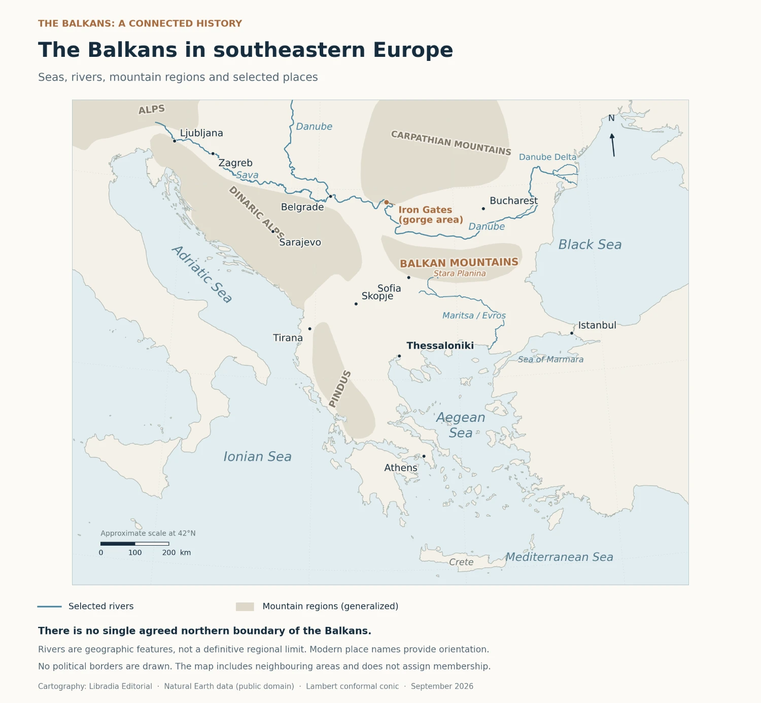
    Begin with the seas. The Adriatic and Ionian lie to the west and southwest; the Aegean opens to the south and southeast; the Sea of Marmara and the Black Sea lie farther east. Inland, mountain ranges, valleys and plains form a varied landscape. The Dinaric Alps, Pindus and Balkan Mountains are distinct features, visible on the orientation map below. Balkan Heritage: geographical overview

    Places commonly included in discussions of the region lie in Albania, Bosnia and Herzegovina, Bulgaria, Greece, Kosovo, Montenegro and North Macedonia, as well as Serbia and Croatia. Romania, Slovenia and European Turkey also figure in broader accounts. Such a list is a guide to the discussion: it does not establish that the whole territory of every named country falls inside a single agreed peninsula. Balkan Heritage: regional scope

    Map of southeastern Europe showing surrounding seas, the Danube and Sava, selected mountain ranges and cities, without a fixed Balkan boundary.
    The Balkans and neighbouring areas, with selected rivers, mountain regions and modern place names. The map draws no political borders or definitive northern boundary of the Balkans. Mountain regions are generalized. Map: Libradia Editorial; base data: Natural Earth (public domain). Open the full-size map.

    Why the northern edge moves

    One geographical convention follows the lower Danube and the Sava, continuing west by the Kupa towards Rijeka. Other definitions choose different rivers or mountain limits. Friedman and Joseph’s survey of the region explains how these alternatives include or exclude different areas. A river boundary along the Danube, for example, leaves most of Romania outside, even though Romanian history and language belong in many studies of the Balkans. Friedman and Joseph, §1.1

    Slovenia makes the overlap especially clear. Its landscapes meet the Alps, the Mediterranean, the Pannonian Plain and the Dinaric Alps. Each connection provides a useful starting point for understanding the country. A discussion of its Adriatic setting can coexist with an account of its Central European or southeastern European relationships. Those perspectives answer different questions about the same place. Government of Slovenia: geographical setting

    Reading this map

    The map includes neighbouring areas and uses modern place names for orientation. Its rivers help locate places; they do not certify cultural membership. To assess another map, look for the author’s definition, the period represented and the reason a particular boundary was chosen.

    A name with a history

    The regional name has its own chronology. The German geographer August Zeune introduced the designation “Balkan Peninsula” in 1808. Balkan was already a mountain name: the range running through central Bulgaria is also known as Stara Planina. Applying that name to a much larger area was a geographical naming decision. It did not mark the birth of the societies living there. Balkan Heritage: Zeune and 1808; Friedman and Joseph, §1.1, note 3

    Over time, the name acquired meanings beyond location. Historian Maria Todorova has examined how “balkanization” came to suggest fragmentation and how descriptions of the region attached wider judgements about backwardness and violence. Such language can make a place sound like an explanation for everything that happens within it. Todorova: public extract

    A history of a particular war still needs particular causes: decisions, institutions, interests and circumstances. Libradia’s account of the July Crisis of 1914, for example, follows diplomatic and military choices as a conflict widened. The regional label alone cannot do that explanatory work.

    Why “Western Balkans” is a narrower term

    Institutional language creates another map. In the European Union’s enlargement context, the Western Balkans refers to Albania, Bosnia and Herzegovina, Kosovo, Montenegro, North Macedonia and Serbia. These are the six beneficiaries listed by the Western Balkans Investment Framework. WBIF: partners and beneficiaries

    This grouping serves a contemporary policy purpose. It cannot be used as a complete list for a history of the wider Balkans: Greece and Bulgaria, for example, remain central to that history. “Southeastern Europe” is another regional designation, often used alongside “the Balkans”; its scope also needs to be stated by the author.

    A river landscape across a boundary

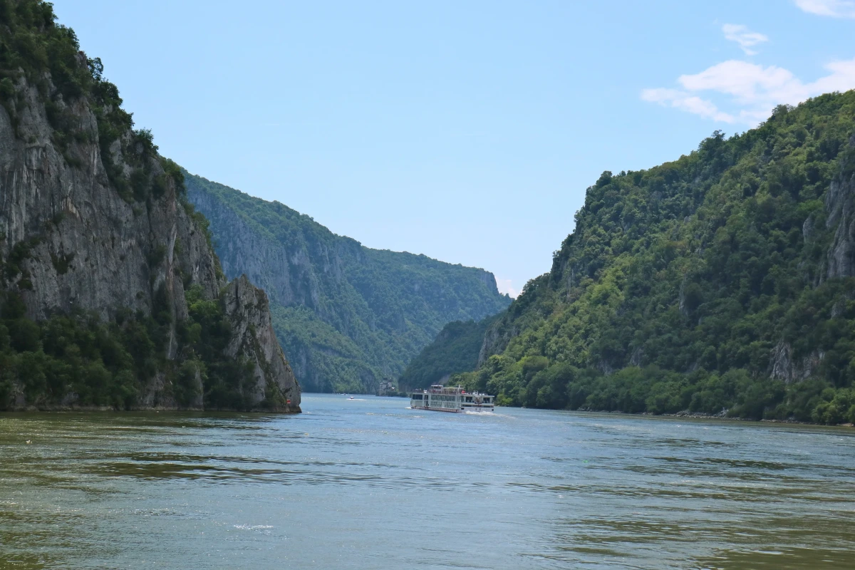
    The Iron Gates offers a concrete place to test these distinctions. The Danube runs through a sequence of narrow gorges and broader valleys here, with Serbia on the southern side and Romania on the northern side. The geopark’s account identifies four smaller gorges and three intervening valleys within the larger landscape. Đerdap Geopark: the gorge

    A river cruise boat travels between steep, wooded cliffs in the Iron Gates gorge on the Danube.
    The Danube in the Iron Gates gorge, photographed on 22 May 2016. This is a contemporary view. Photo: Erik Cleves Kristensen, “Most narrow point of the Danube on Iron Gates”, via Wikimedia Commons, CC BY 2.0. Resized and converted to WebP; no crop.

    The photograph gives the river a scale that a thin blue line cannot convey. Wooded slopes descend to the water, and a boat passes between the cliffs. It is a view from 2016. Following this landscape into earlier history will require evidence about the settlements, vessels and river conditions of each period. The present scene helps us locate the questions.

    Thessaloniki and the histories within a city

    Farther south, Thessaloniki brings the Aegean into view. Its White Tower belongs to the city’s Ottoman history. The museum’s account places the tower at the meeting point of earlier eastern and sea walls, showing how differently the structure once related to its surroundings. Today’s photograph records a later urban setting. White Tower Museum: history

    The illuminated White Tower in Thessaloniki beneath a dark blue evening sky, with pedestrians and traffic in the foreground.
    The White Tower in Thessaloniki at blue hour, photographed on 12 October 2020. This contemporary view shows the landmark in its present urban setting. Photo: Annatsach, “The White Tower of Thessaloniki – 1”, via Wikimedia Commons, CC BY-SA 4.0. Resized and converted to WebP; no crop.

    The city’s communities provide another way into its past. Thessaloniki, also widely known historically as Salonica, was home to a major Sephardic Jewish community. Devin E. Naar’s research examines how the city’s incorporation into Greece in 1912 changed the setting in which its Jews understood community and citizenship. The University of Washington’s account of his work describes sources in Ladino, Greek, French and Hebrew. University of Washington: Jewish Salonica

    That example gives a history of the Balkans a different scale: a city, several languages and people negotiating a political change. A map shaded by present-day states cannot by itself reveal those experiences.

    Connections in ordinary speech

    The linguistic landscape also extends beyond the South Slavic languages. It includes Greek and Albanian, Romance languages such as Romanian and Aromanian, and varieties of Romani, Turkish and Judezmo, or Judeo-Spanish. Their histories are part of the region’s history. The Balkans cannot be reduced to the former Yugoslavia or to a single language family. Friedman and Joseph: languages and contact

    Linguists use the term sprachbund, or linguistic area, for languages that have developed similarities through contact. In the Balkans, these include patterns of grammar as well as vocabulary. Friedman and Joseph emphasise sustained local interactions and multilingual communities as processes behind this convergence. Similarities vary between places and dialects; speaking a language found in the region does not mean sharing every “Balkan” linguistic feature. Friedman and Joseph: reassessing the sprachbund

    Reading the region together

    “Where do the Balkans begin?” therefore needs a second question: what are we trying to understand? A physical peninsula, an institution’s partner list and a network of speaking communities have different boundaries. Clear definitions make comparison possible without requiring every place to have one permanent regional identity.

    The Balkans: A Connected History begins with this orientation. Later chapters will follow particular routes, settlements, monuments and communities through defined periods, asking how people lived within and across changing boundaries. The next planned chapter turns to roads, rivers and sea routes, and the practical work of connecting places.

  • Beyond Mesopotamia: The World Around 3500 BCE

    Choose 3500 BCE on a timeline, then look across a map. The date stays the same, but the human landscape changes. In southern Mesopotamia, settlements were growing towards the urban world explored in our opening articles. Elsewhere, communities organised food, work and gathering places in different ways.

    A world history needs those differences. It also needs care with dates: famous monuments can make distant societies feel contemporary even when centuries separate them. This tour uses the centuries around 3500 BCE as its starting point, with later developments explicitly marked. It is a selection of places, not a complete inventory of the inhabited world.

    At a glance

    Time
    The fourth millennium BCE, centred on c. 3500 BCE; later comparisons are identified.
    Places
    Mesopotamia, Egypt, South and East Asia, southern Britain and coastal Peru.
    Question
    What changes when we look beyond the first Mesopotamian cities?

    One date does not mean one stage of history

    Terms such as Neolithic, Chalcolithic and Bronze Age describe regional archaeological sequences. Their dates and meanings vary from region to region. Nor does the presence of pottery, farming or a large monument automatically identify a city.

    For this comparison, three questions are more useful: how did people obtain food, how did they organise shared activity, and what evidence survives? Asking the same questions helps us compare communities without assuming they were all trying to become Uruk.

    Mesopotamia: cities take shape

    Southern Mesopotamia provides our starting point because the later fourth millennium brought an especially visible concentration of large settlements, substantial public buildings and economic administration. Getty places this combination around 3400–3000 BCE. The date range helps distinguish the cities of the late fourth millennium from settlements several centuries earlier. Getty: Mesopotamia — Civilization Begins

    By around 3200 BCE, Uruk had monumental mud-brick architecture and administrative records on clay. Its growth raises questions about supplying people and coordinating labour, but does not tell us how every other large community worked. Our article on Uruk explores that local setting in more detail. The Met: Uruk — The First City

    Egypt: communities along the Nile before the pyramids

    Around 3500 BCE, Egypt was in its Predynastic period. Farming and herding had long been part of village economies, alongside resources such as fish. During the Naqada II period, differences in tomb size and contents suggest that access to wealth was becoming more unequal. Pottery decorated with boats and other motifs offers another view of this changing society. The Met: Egypt, 8000–2000 B.C.

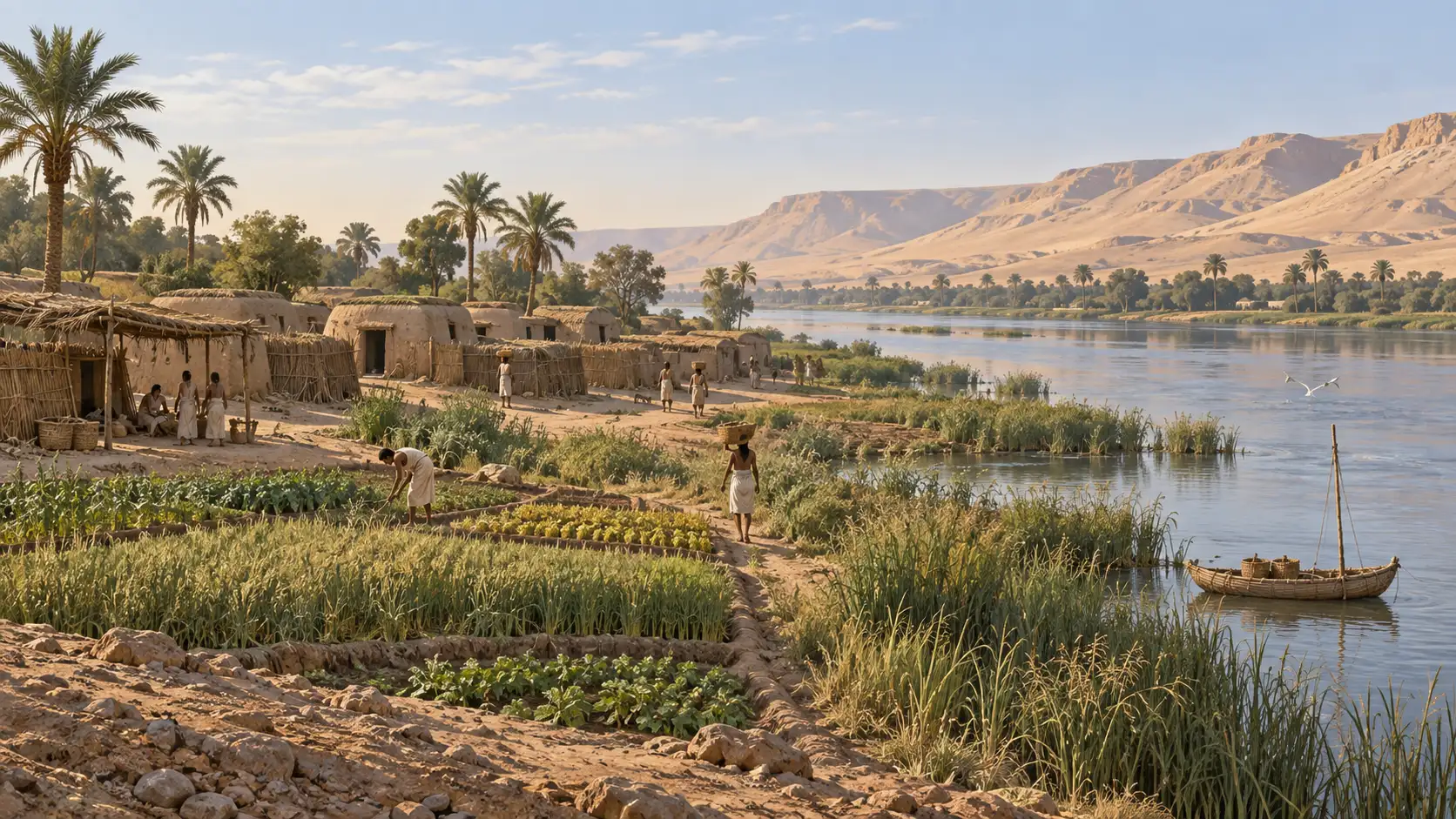
    The imagined Nile settlement below brings cultivated ground, homes and water into one view. It illustrates the setting of village life rather than a particular excavated site.

    AI illustration of low buildings, cultivated land and people beside the Nile in a Predynastic setting.
    AI-generated interpretative illustration for Libradia: an imagined Predynastic Nile settlement. The buildings, people and arrangement are not a reconstruction of a specific excavated village.

    This was not yet the Egypt of the Giza pyramids. The Met places the Early Dynastic period from approximately 3100 BCE, with the great pyramid-building age later still, in the Old Kingdom. Looking at Egypt around 3500 BCE means taking its earlier communities seriously, rather than filling the landscape with monuments familiar from a different millennium. The Met: Egypt, 8000–2000 B.C.

    South Asia: the settlements before Harappa’s great city

    At Harappa, in present-day Pakistan, excavation separates early occupation from the much later urban settlement. Jonathan Mark Kenoyer and Richard Meadow identify a Ravi phase conventionally dated approximately 3300–2800 BCE in their published chronology, preceding the Harappan urban phase from around 2600 BCE. The Ravi evidence therefore takes us slightly beyond our starting date; Harappa’s mature urban settlement lay farther in the future. Kenoyer and Meadow: The Ravi Phase — A New Cultural Manifestation at Harappa (2000)

    The early finds include bone tools interpreted as equipment for activities such as basketry and textile work. Small objects deserve a place beside impressive city plans: they reveal skills and work that would be easy to overlook if we began only with a settlement at its greatest size. Some proposed tool functions remain interpretations rather than directly observed uses. Kenoyer and Meadow: The Ravi Phase — A New Cultural Manifestation at Harappa (2000)

    East Asia: different relationships with food and place

    Across the Japanese archipelago, Jōmon communities combined fishing, hunting and gathering with substantial traditions of pottery and other crafts. Pit dwellings and the remains of food processing show that a settled community need not be defined by the same cereal agriculture that supported Mesopotamian cities. Jōmon is itself a broad label covering considerable regional and chronological variety. The Met: Jōmon Culture

    On the Chinese mainland, Liangzhu provides a later comparison within the fourth millennium. UNESCO dates the site complex approximately 3300–2300 BCE and describes a regional society supported by rice cultivation, with major earthworks, water management and marked differences in burial treatment. The remains accumulated over time; the whole complex should not be imagined as already complete in 3300 BCE, still less in 3500 BCE. UNESCO: Archaeological Ruins of Liangzhu City

    These examples change the comparison. The useful question becomes how particular communities used local resources and organised collective projects, rather than which one was furthest along a single path.

    Southern Britain: a monumental landscape before Stonehenge

    In the landscape around the future Stonehenge, people built long barrows, cursus earthworks and a causewayed enclosure in the centuries around 3500 BCE. Such monuments show investment in places beyond individual homes. English Heritage dates Stonehenge’s major circular earthwork to about 3000 BCE and its famous stone settings to about 2500 BCE. English Heritage: History of Stonehenge

    Large construction projects therefore do not belong exclusively to cities. A monument can reveal collective effort without establishing that its builders lived under a Mesopotamian-style urban administration. Its form and setting need their own explanation.

    Coastal Peru: Caral in a later period

    Caral, in Peru’s Supe Valley, is often included in discussions of early urban societies. It belongs in Libradia’s wider story, but not as a fully developed contemporary of our 3500 BCE starting point. UNESCO places the development of the site approximately between 3000 and 1800 BCE. Its monumental platforms and sunken courts offer a valuable comparison for a later period. UNESCO: Sacred City of Caral-Supe

    The later date of Caral does not imply an absence of earlier communities in the Americas. It tells us where this particular site belongs in a comparison of monumental settlements.

    What comparison reveals

    The places in this tour are not entries in a competition. Some preserve conspicuous buildings, others rich burials or traces of ordinary work. Those differences affect what we can say about them, as well as what modern visitors notice first.

    Reading across regions also means resisting a familiar visual shortcut: pyramids for Egypt, stone circles for Britain, planned streets for the Indus. Each belongs to a sequence of change. Once we put dates back into those pictures, the past becomes less like a row of finished civilisations and more like communities making choices under particular conditions.

    The opening series has followed settled life into the world of early Mesopotamian cities. From here, we can look more closely at the activities that sustained them: feeding people, organising households and moving goods between places.