
Tikal’s temples rise above the forest of northern Guatemala. Their builders also reshaped the ground closer to people’s feet: plazas, channels, dams and reservoirs helped gather and retain water. The city’s monumental centre belonged to a wider inhabited landscape, with residences extending beyond the great ceremonial spaces. Supplying that population required attention to the months when rain was scarce. UNESCO: Tikal National Park
The reservoirs make it possible to investigate that work. Excavated structures reveal construction and repair, while sediments preserve traces of minerals, plants and contamination. Together, they expose two connected problems. The city needed enough water to last through dry periods, and that water needed to remain usable.
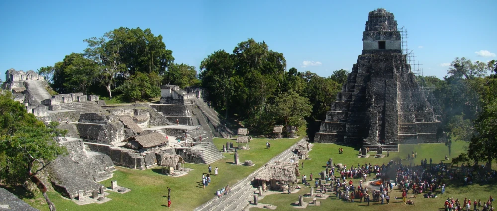

A city and its water landscape
The focus here is Tikal during the Maya Classic period, approximately 250–900 CE, with earlier reservoir development as background. A catchment is the area from which water drains towards a particular basin. At Tikal, construction altered both the basins and the surfaces supplying them.
Living with a seasonal supply
A tropical forest does not guarantee a dependable water supply in every season. In the southern Maya lowlands, rainfall varies substantially over the year. Tikal’s elevated centre had no large perennial river or lake immediately beside it. Stored water helped bridge the dry months, while rainwater moving over the inhabited landscape brought its own challenges. Water could carry sediment and waste as well as replenish a reservoir. Lucero, Gunn and Scarborough: seasonal water management
Archaeologists have also identified a small spring in the Temple Reservoir area that may have attracted early settlement. As the city grew, water management became much more extensive. The system developed through successive modifications to a landscape that already had slopes, depressions and natural drainage. Scarborough and colleagues: the Temple Reservoir and early spring
Turning the city into a catchment
Research published in 2012 traced how Tikal’s builders adapted natural drainage and used constructed surfaces to direct runoff. Paved areas helped channel rain towards storage, while dams held water at different elevations. The Palace Reservoir, below the Temple Reservoir, was retained by a substantial dam. Reservoirs and monumental construction formed parts of the same altered terrain. Scarborough and colleagues: reservoir construction
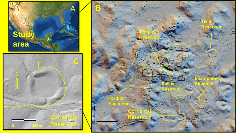
The research map helps separate individual reservoirs and their catchments. Corriental, for example, occupied a different part of the system from the Temple and Palace reservoirs. That distinction becomes important when their sediments are compared: water from different surrounding surfaces did not necessarily acquire the same materials or contaminants.
A catchment therefore extends the history of a reservoir beyond its visible edge. Conditions uphill could affect what arrived in the basin. The people maintaining a water supply had to work with this relationship between the storage space and the landscape feeding it.
Storage needed continuing work
Excavation shows that Tikal’s water structures were repaired and remodelled. At the Palace Dam, investigators found evidence of collapse followed by an attempt at repair. They also interpret the arrangement between the Temple and Palace reservoirs as permitting work on the lower basin while water remained held above. Such interpretations concern the operation of a system, not simply the size of its original construction. Scarborough and colleagues: Palace Dam and maintenance
Maintaining usable storage meant more than waiting for rain. A basin could lose capacity as material accumulated, and damage to a retaining structure could change where water flowed. The archaeological traces of repair bring recurring work into a history often told through the completion of impressive monuments.
Mineral clues to filtration at Corriental
In a study published in 2020, Kenneth Barnett Tankersley and colleagues reported zeolite minerals and coarse quartz in Corriental’s sediments. They proposed that these materials had been brought to the reservoir for filtration. Zeolites have porous structures and chemical properties that can capture certain contaminants; their presence here gives the argument a specific material basis. Tankersley and colleagues: mineral evidence and filtration
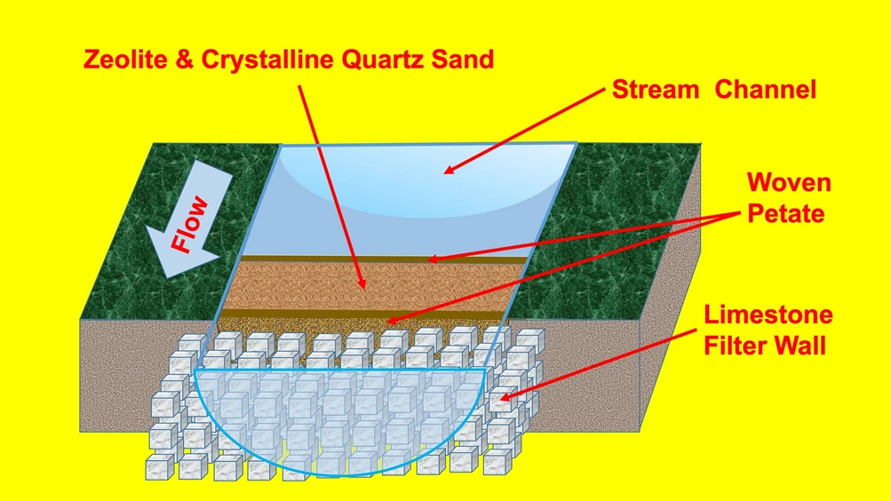
The diagram illustrates the authors’ proposed arrangement. It places filtering material near an inlet, held by woven material and stonework. The complete structure shown was not recovered intact. The minerals are observed evidence; the detailed arrangement is a reconstruction intended to explain how they could have functioned.
This distinction leaves room to appreciate the proposal without turning it into a modern performance certificate. We cannot use the diagram to calculate how effectively every contaminant was removed in every season. It presents a plausible technique for improving water within a much larger system of collection and storage.
Trees were part of the urban setting
A different investigation asked what grew near the Temple and Palace reservoirs. In 2021, researchers analysed environmental DNA, fragments of genetic material preserved in sediments. Their results supported the presence of native forest vegetation around these central water spaces, rather than a simple picture of reservoir banks planted entirely with crops. Maize was not clearly identified in the analysed samples. Lentz and colleagues: environmental DNA and reservoir vegetation
The authors suggest that trees could have provided shade and other benefits, alongside their role in the landscape. More specific ideas about recreational or symbolic uses remain interpretations. The evidence supports a city in which substantial architecture and vegetation existed close together. Modern forest covering abandoned buildings should not obscure the possibility of trees within the inhabited ancient city.
Water quality varied between reservoirs
Storage also created vulnerabilities. Another 2020 study, led by David L. Lentz, found elevated mercury and phosphate in the Temple and Palace reservoir sediments, together with DNA evidence of cyanobacteria belonging to groups capable of producing toxins. The researchers identified serious contamination associated with the later centuries of occupation. They proposed that mercury-containing cinnabar pigment used in the urban centre was an important source of pollution. Lentz and colleagues: reservoir contamination
Corriental produced a different pattern, with substantially less evidence of the contamination affecting those central reservoirs. The findings therefore describe variation within Tikal’s water supply. They do not justify declaring that every reservoir was equally polluted.
The methods also set limits. Ancient sediments preserve chemical and genetic traces, rather than a sample of water drawn from someone’s drinking vessel. Evidence of potentially toxic organisms is significant, but it cannot identify who drank from a particular reservoir or establish a diagnosis for an individual inhabitant.
Water and the city’s changing future
The decline of Tikal’s population and political institutions around the end of the Classic period occurred within wider changes in the Maya lowlands. Researchers connect episodes of drought with stresses on water supplies, farming and royal authority. The contamination findings add another possible pressure; they do not settle the whole question of why people left particular places. Lucero, Gunn and Scarborough: drought, rulers and farming communities
The loss of a royal centre also differs from the disappearance of a people. Maya communities continued after the decline of Classic cities and remain part of the region’s present. Water history is most revealing here when it follows changing choices and circumstances, rather than compressing many lives into a single moment of “collapse”.
Tikal’s reservoirs sustained urban life for centuries. Their remains preserve both successful adaptation and problems that accumulated over time. Looking beyond the temples brings the city’s dependence on maintenance, vegetation and water quality into view. For an earlier and very different urban water setting, explore the wells and drains discussed in the cities of Harappa and Mohenjo-daro.